Shey-phoksundo National Park is located in the Trans-Himalayan region of northwest Nepal. It covers an area of 3,555 km2, making it Nepal’s largest national park. Established in 1984, it preserves a unique Trans-Himalayan ecosystem with a wide variety of flora and fauna. The Park’s diverse biotic communities are supported by the Park’s climatic differences, altitude variations, and different zoo-geographical regions. A buffer zone of 1349 km2 was declared around the park in 1998, comprised of forests and private lands. Both the park and the local community are responsible for managing the buffer zone. Together, they develop community development programs and manage cultural and natural resources.
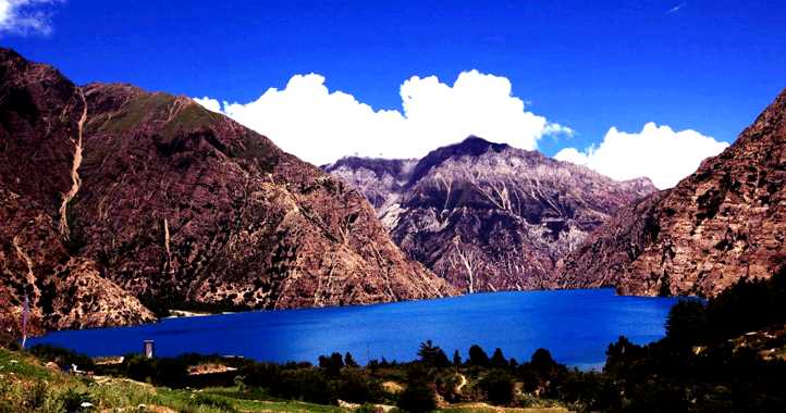
Shey Phoksundo National Park provides a variety of spectacular landscapes. The park has an elevation range of 2,130m in Ankhe to 6,883m at the summit of Kanjiroba Himal. Most of the park is located north of the Himalayan crest. Phoksundo Lake, Nepal’s deepest and second largest lake, lies in the upper regions of Suligad. Near the lake’s outlet is Nepal’s highest waterfall. Rivers in the park include the Khung, Nmajung, and Panjang Rivers, tributaries of the Thuli Bheri River, and the Langu River, which drains the high Upper Dolpo plateau to the east and flows west. The magnificent turquoise colour of Phoksundo Lake, along with its spectacular scenery, rank the park among the most scenic in the world. This scenic region is home to the typical Tibetan village of Ringmo. Near the lake, Nimala and Kagmara pass the Lower Dolpo trek, there are numerous glaciers. The park contains many gompas (monasteries) and religious areas. The most famous is Shey Gompa, built in the 11th century. About 900 years ago, Thashung Gompa was built to conserve wildlife near Phoksundo Lake.
The park has a wide range of climatic conditions due to its location on both the northern and southern sides of the Himalayan crest. Most of the precipitation in the area occurs during the monsoon (July-September), even though the Dhaulagiri Mountain and Kanjiroba Ranges provide a massive barrier preventing most of the rain from reaching the Trans-Himalayan region. In the park, there is a transition from a monsoon climate with 1500mm of annual precipitation in the south (Suligad) to an arid climate with less than 500mm. a year on the northern slopes. The winters are quite severe, with frequent snowfalls above 2,500 m. The temperatures remain below freezing above 3,000 m. for most of the winter.
Flora & Fauna: The park contains a diverse range of flora. In the northern regions of Nepal are barren lands in the Himalayas and Trans-Himalayan slopes, dominated by Salix, Juniper, white Himalayan Birch, and the occasional silver fir on the high meadows of the Himalayas. Only 5% of the park is forested, with most of it located in the southern portion. Suligad Vally’s flora is composed of blue pine, spruce, hemlock, cedar, silver fir, poplar, rhododendron, and bamboo. There are also 286 plant species of ethnobotanical significance in the park. This park is home to many endangered species including the snow leopard, grey wolf, musk deer, and blue sheep. It is also home to the goral, great Tibetan sheep, Himalayan tahr, leopard, jackal, and Himalayan black bear. Paralasa nepalaica, the highest flying butterfly in the world, is one of 29 species of butterflies in the park. Over 200 species of birds live in the park, including Yellow-throated martens, Tibetan partridges, wood snips, white-throated tits, wood accentors, and crimson-eared rosefinches.
Accommodations are available in Dunai, Sangta, Chhepka, and Ringmo. In the park, there are campsites with rubbish pits, toilets, and shelters. The trekking lodges in Dunai, Chhepka, and Ringmo provide food and limited supplies. The park has offices in Suligad, Chhepka, Palam Ringmo, and Toijem. At the Palam headquarters, there is a small visitor center.
From Nepalgunj, the easiest way to reach the park is by air to the Juphal airstrip in Dolpa, followed by a half-day walk to the park entrance at Suligad.
More than 9,000 people live in the park, and their villages are among the highest settlements on earth. There are many practitioners of Bon Buddhism in the park, which traces its roots back to Animism and Buddhism. It is estimated that 18,000 years ago, the Bon-po religion of western Tibet was founded, forming the entire cultural foundation for Tibetan Buddhism. There are sacred monasteries, thangka paintings, and chortens dotted throughout the countryside. Tibet trade and agriculture are significant to the local economy. Caravans carrying salt are also popular here.
Leave a Reply